![]() Original
Press Release
Original
Press Release
June
25th 1997
WATER TRAILS OF THE ANASAZI
Http://144.38.20.128/cody/bobby.html
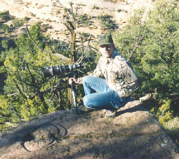
In October of 1996, photographer Bob Ford of Fredonia AZ, made what could be considered one of the most amazing discoveries in modern American archeology, by identifying a system of universal trail markings, thought to guide travelers to water, as they cross the Arizona Strip, left by it's first known inhabitants, the Anasazi Indians.
In many ways it makes sense that someone like Bob would make such a discovery. Where other men go home and watch football after work, Bob goes home, gathers his photographic equipment and heads out to catch a few pictures before the sun goes down. He has combined his love for photography with the easy accessibility of the Arizona Strip and amateur archeology.
Over his lifetime Bob has visited several hundred native American sites on "The Strip" which covers Northern Arizona, Southern Utah and Southeastern Nevada. His extensive knowledge comes from 30 years of experience in the field taking photographs of sites in the area.
This field experience is what allowed him, from the sheer mass of sites he is familiar with, to begin to make the mental connections between glyphs and sites and their geographical relation to others in the same area.
Bob relates that one afternoon, as he was photographing some glyphs, he noticed that a certain glyph was pointing toward a single tree on the horizon. A notable instance considering how few trees exist on the strip, but what caught his attention was that this tree was only visible at this exact point because of a "saddle" in the ridge of the horizon.
Bob says
it struck him as add because he was sure he had photographed another site,
some 25 plus miles away, on the other side of the ridge, that had the
same glyph, and he thought it pointed at the same saddle could it be pointing back this same way?
| TEAM MEMBERS | WORKS CITED
CONTACT US @ WATER GLYPHS