Ancient Navigation
System Found On
Arizona Strip
In May, 2001,
a small private research team completed a 5 year survey of ancient rock carvings.
The team was investigating the reoccurrence of the same glyph repeatedly in
an area more than 5,000 miles square along the Utah, Arizona and Nevada borders
known as the Arizona Strip. Local resident Bob Ford, together with Dixon Spendlove
made the initial discovery in in the spring of 1997, originally
publishing their findings to the Internet in June of the same year.
These "glyphs"
are not similar to any other glyphs known to have been published to date. They
are absolutely unique, both in size and location. Where as other petroglyph
or pictograph panels are usually found on a vertical wall, under a cliff or
overhang, where they will be protected for the natural elements, these are found
only on the edge of cliffs, along the edge, carved directly into the surface
fo the horizontal rock layer. They are usually 48 inches long by 24 inches wide,
with the depth of the groove that makes them nearly an inch deep... HUGE when
compared with other similar instriptions.
The symbol is simlplicity
itself; a complete circle, cut in half with a single straight line, with the
line extending beyond the edge of the circle a distance equal to the diamiter
of the circle. If it were three dimensional, it would look approximately like
a beachball with a javelin stuck in it.
The last ingredient is
the dot. Somewhere to the left or the right of the line, will be a dot. Sometimes
the dot will be inside the circle, somethimes outside the circle. Occasionally,
there will be more than one dot, or more than one circle... But there is no
mistaking the glyph. We are talking about something almost the same size as
a common "STOP" sign, etched into the solid rock of a cliff top, within
a few feet of the edge... once you know what to look for, they are hard to miss.
Working with Mr. Ford and Mr. Spendlove,
the team has located. photographed and cataloged more than 128 of these glyphs.
The team is also gathering data about exact latitude & longitude using
Trimble GPS units,
(accurate to within 2 meters). These
geo-spatial data were then corrected for Atmospheric anomalies by Southern
Utah University's GIS/GPS Lab, using the Dixie
National Forest Service base station, located in Cedar City Utah. Using
this corrected data, maps of the known glyphs have been created and dispersed
to members of the research team for further analysis. Included in these maps
are AUTO CAD renderings of compass azimuth readings, indicating a "line-of-site"
from each glyph.
The initial data seems to reveal a
very high correlation between the "way the glyph points" and known
springs or wells in the area... suggesting a very complex system of navigation
laid out by the earliest known inhabitants of this desert, and from thence comes
the term coined by the team... "water-glyphs".
As these maps reveal more information
regarding the relationship of these glyphs to known water sources, mineral deposits,
native community ruins and each other, appropriate information will be made
available to the public via this web site.We invite visitors to browse the material
at this web site to learn more about the history and thought behind this startling
discovery.
Many theories
as to their origin and exact meaning have arisen, both among local residents
and among team members. As Bobby is fond of saying; "If you see one or
two, you can easily theorize their meaning, but the more I see of them the less
I know for certain." Here we will include several of the most common, which
have either been considered or are currently under consideration by the research
team, and invite the reader to form their own opinions;
Spanish
Mine Markers
Some early critics of the teams work suggested that these marks are "nothing
more than scribbling" left over from old spanish mining operations
The many evidences of Spaniards mining gold in this area during the late
14th and early 15th centuries include; tree blazings, rock inscriptions and
cryptic maps to "lost mines" that have already been chronicled in
countless books and will not be recounted here. There is no question that
the spanish were in this area, the critical the question is "Were
these glyphs made by Spanish Explorers or by someone else before them?
In the spring of 1999, while studying the petroglyph writings of a known
Basket Maker site [600900 AD], among more than 200 other images, Dixon
Spendlove made a startling discovery.. he found an unmistakable 5 miniature
version of the glyph. Clearly, the Basket Maker people who occupied this site,
prior to any spanish exploration, were at the least aware of
the existence of the glyphs. Since this initial find, 4 other similar inscriptions
have been found.
There is no question that the marks pre-date european occupation of the area.
Sacrificial
Alters
The first member of the
team to actually see one of these glyphs was Dixon Spendlove. As a boy
growing up in the area, he was shown the most commonly known example in the
area, which was found on what was then "Judd" property in Johnson Canyon.
At the time, a very few
examples of the glyph were known to exist, and no one had any idea of their
true purpose.
However, because this
glyph is situated above a known ruin with a very unique burial site, in which
the bodies are interred in tubes, or circular shafts carved into the bedrock
of the cave walls and floor, Stacked one on top of the other, almost everyone
who had seen the glyph believed that it was used as an "altar" or
sacrificial stone in some ancient practice of "blood sacrifice"
Stories
were common of how the sacrifice was laid on the "altar" or circle
portion of the glyph, their heart cut out and placed in the hole at
back of the circle, letting the blood slowly run in down the straight
line to the edge of cliff.
Over time, such dramatic
stories naturally become local legends.
The local area newspaper,
The Southern Utah News
, published a series of articles by a local Scout leader Royce
Young in the early 1990's which included an account of his local scout
troop searching for these glyphs in Johnson Canyon. Mr.
Young's scout troop found and mapped several glyphs and published their conclusions
in that article, which we have included here as apendix
A. This artical includes thier Solstice
Marker theory.
While we salute these scouts for their
efforts, and logical conclusions, our research team
has located
over 17 different glyphs in Johnson Canyon alone, most of which are located
in such a way that the glyph's center line is actually running uphill
and away from the cliff edge...which sort of ruins the
whole altar effect.
Additionally,
we have access to data on a hundred and twenty more glyphs than they did.
Based on the observations of the 128 known glyphs, this theory is not considered
valid by our research team, and we do
not agree with the Royce Young artical promoting
a solstice marker theory.
However, it makes a dramatic
Indiana Jones type story, and
many of the local residents still support this theory...
and we applaude the scouts for thier work.
Solstice
Markers
By far and
away, the most popular theory proposed for the purpose of the glyphs is
that they are solstice markers.
While there
are clear indications that the ancient inhabitants of the southwest were
accomplished astronomers,
including the much publicized discoveries in Chaco
Canyon and in Central
Texas, our research team does not feel that this
is a valid theory. To
date, more than 128 glyphs have been located, pointing to almost as many
different azmithuths on the compass, ranging from 0° to 359°.
Although
the team does not rule out the possibility that some of
the glyphs may have some calendarical significance,
(perhaps lunar instead of solar), current data would
suggest this a general blanket theory that they ALL were used in this
way would seem impossible. Solstices occure at very specific times of
the year, and there are only four... yet we have glyphs pointing in all
different directions.
The basic
principals of a solstice are fairlry simple: The Earth is actually nearer
the sun in January than it is in June, [by three million miles] , and our
Earth leans slightly on its axis, [ 23 degrees and 27 minutes off perpendicular
to the plane of it's orbit], so as the Earth orbits the Sun at this odd
angle, the Sun appears to "move" northward or southward in the sky.
More precisely,
a "solstice" is the point in Earth's orbit around the sun at which
this apparent movement of the SUN stops ... and changes direction.
This fundamental
principal is important because this apparent movement of the Sun
is relative
to your position on the surface of the earth. While glyphs have been
found over a 5,000 square mile area, the latitude of known glyphs never
varies more than 20 miles from
37°00'04" latitude, which for the purposes of the solstice theory, is
a negligible deviation,
and can not account for the 90 plus variations in compass readings. Clearly,
these glyphs were used for something else.
Prayer
Shrines
By Dixon Spendlove
The Hopi Survival Kit
by Thomas E. Malls & Dan Evehema speaks of a period of time the Hopi
refer to as their migrations period. This time occurred before their
roots were solidified at the village of Old Oribi... over 2,000 years ago.
According to the Hopi story of emergence from the underworld, when
the Hopi lived beneath the surface of the land, they could hear "Masaaw"
walking on the surface and they also desired to emerge to the surface. To
accomplish this they emerged from a reed to the surface thru a hole called
the Sipapu. To this day, the Hopi are told to offer their prayers back
to the underworld by talking back thru the Sipapu or reed to the original
hole of emergence in the Grand Canyon
There are several written accounts of Hopi culture, were the Hopi
were told by Masaaw to make "marks upon the rock
to show where they traveled" and lived.They were also to make
shrines & offer prayers.
Could this sign be representative of a prayer shrine? With the hole in
the circle being the Sipapu and the straight line being the reed and the
line always running to the edge of the rock
possibly signifying the Grand
Canyon. Are the differences among glyphs, of additional lines, circles,
or holes, simply showing use by different clans?
The research team found ( after returning to the glyphs many times over
the last six years) that several of these glyphs are being used as native
"holy places".
For what should be obvious reasons of respect, no evidence of this
fact will be presented here. However, perhaps by coincidence, the
Paleo-Hebraic theory again lends
support to this theory...
The Hebrew letter Kolph  written in Paleo-Hebraic is
  , and Rabbin associated the Kolph with "Temple Offering":
"If a man were to find a Jar with a
written on it, the contents were considered 'consecrated unto God'.
(Maaser Sheni 4:11) The key phrase here is 'Kodesh
La HaShem'
or 'Holiness to the Lord' ".
It has also been suggested by Midrash Alpha
Beit, that
"...since the temple (in Jerusalem) had been destroyed,
and the offering no longer available to make our prayers effective, everyday
[the faithful] should recite 100 blessings as a substitute."
According to Hebrew Gemetria,
= 100.
Bird
of Prey Snares
By Dixon Spendlove
One of the original theories
proposed by Dixon Spendlove in 1998, was that these marks were used by the ancients
to trap or snare eagles, hawks and other raptors to acquire the sacred feathers
they needed for religious ceremonies.
While Hollywood has shown
us instances of young braves scaling sheer canyon walls to steal feathers from
the nests of eagles, such things are completely removed from reality.
Dixon observed that many
of the glyphs, were
located on or near the edge of mesas, cliffs or buttes which are great
hunting locations for birds of prey. Several of the glyphs were situated in
such a way that they would allow a man an excellent hiding position over
the edge of the precipice.
A man could conceal a strong
cord in the groove of long line of the glyph... following the circle to
make a loop for a snare.. and place a small rodent or sparrow, tethered
to a rock or weight in the hole inside the circle... Then wait out
of site over the edge of the precipice... Allowing the foundering animal
to act as bait for any passing raptors.
The Hopi have demanded,
by legal action, their religious right to trap eagles and hawks from "traditional
locations on lands that are now used by Navajos and other tribes.
Why not just use any hilltop
available to them? The Hopi reservation has more than enough suitable
mesas...
Unless, there was something
special about a particular hilltop... Something that made it a sacred
site... Something that marked it as Holy.
While not all the glyphs
could be used for this purpose, a surprising number of them would work nicely
for this purpose. Again, in an amazingly odd coincidence, the Paleo-Hebraic
theory lends support to this idea...
The Hebrew letter Kolph
written in it's original Paleo-Hebraic form is
, ...And it's Notarikon
ideogram is noose or snare.
Bi-directional
Markers
by Dave Maxwell
David Maxwell, Director of Southern Utah University's GIS/GPS Lab, offered
this insight regarding the glyphs within hours of spending his first day with
the team.
Viewing the glyphs as a professional map maker, Dave pointed out that in
order for these glyphs to function as navigational markers, they would have
to function in both directions
"going" or "returning"
from a location. Having seen less than 7 glyphs, Dave hit upon something
other team members had already witnessed.. but not understood.
If Dave's theory was correct, then the straight line would have to represent
the topography in both directions
In other words, the glyph would have to be created and positioned in exactly
the right location so that it could be read by travelers headed in either
direction
"moving" it even a few inches would destroy it's integrity.
Other team members had already found examples of this fact. In particular,
where a glyph had fallen, and where it would have clearly been much easier
to simply move the mark a few feet, the original creator of the glyph had
taken great pains to have the glyph "line up" with something and had literally
"wrapped" the circle portion of the glyph around the rock.
Dave also speculated that the that the circle would most likely represent
the user's field of view while standing on that point
what we would today
call horizon" and that the dot(s) might indicate the position or distance
to an object in relation to the visible horizon
Oddly enough, this theory was later corroborated by the
Paleo-Hebraic theory.
Paleo-Hebraic
Symbols
By
Cody Spendlove
In his book "Written by the Finger of God", Joe Sampson, introduces
the idea, that in order to understand some ancient writings, the scholar must
be familiar with an Hebrew writing technique called "Kabbalah".
According to Sampson, many times, because of space limitations or difficult
inscription surfaces, such as writing on metal plates or stone, ancient Hebrew
Rabbis would "code" material by combining several separate glyphs into a single
"ideogram". [see example at right edge of page
] In order to be able to understand the message of the glyph, the reader
must be able to look at the ideogram and mentally "unfold" the different parts
that make up the glyph, "decoding" the author's true meaning.
Sampson relies heavily on the earlier works of such scholars as Adolphe Frank
(The Religious Philosophy of the Hebrews), William
H. Brownlee, & A.E. White (The Holy Kabbalah)
to explain the mysteries of these "Kabbalistic Rabbis" and their cryptic "encoding"
thought process, including both Notarikon & Gemetria
techniques. Sampson also cites a little known work, commonly referred to as
the book of "Egyptian
Alphabet and Grammar", more recently referred to as "The
Kirtland Egyptian Papers."
The work was published in 1844, when very little was known of the ancient
art of Kabbalah, and even less of egyptian. This obscure work proports to
be a collection of the working notes of Joseph
Smith, founder of The Church
of Jesus Christ of Latter Day Saints. Smith claimed to be a prophet of
God, as such, also claimed the ability to translate ancient scripture through
the use of a devise known as the "Urim
and the Thummim" as Abraham of old. Smith published his complete translations
as The Book of Abraham
in "The Pearl of Great
Price", but his notes, written in the margins while translating,
are what were eventually published as the "Kirtland
Egyptian Papers."
Despite having no explanation of how ancient hebraic symbols might have gotten
to the american southwest desert, and ignoring the team's differing opinions
as to the "divine" nature of Smith's translation, these published notes provide
amazing in sites into the possible paleo-hebraic meaning of these glyphs...
In the late second
and early third decade of 1800, Antonio Lebolo was an Italian excavator working
for the Bernardino Drovetti, French consul general in Egypt. Their digs
were known to be in El Gournah, on the west bank of the Nile, across from
the ancient city of Thebes, which is the present city of Luxor,
After hours, on
his own time, Mr. Lebolo unearthed
a number of Ptolemaic mummies (from the period of
Greek influence in Egypt) , which became part of his personal collection.
These mummies appeared to be members of the priestly class, who took great
care to preserve their important papyri documents.
After Lebolos death,
an Italian man in Philadelphia was commissioned to serve as an agent for the
Lebolo family to sell the mummies in the United States where 11 of these mummies
and two papyrus rolls eventually found their way into the hands of a
Mr. Michael Chandler.
Chandler began a traveling exhibition,
in which, over a two year period, he sold the mummies to various agencies,
including two to the Academy of Natural Sciences in Philadelphia. By
the time Mr. Chandler arrived in Kirtland, Ohio, July 1835, he had only
four mummies left.
While visiting the exhibit, Joseph Smith
told church leaders then present, that he felt inspired that these scrolls
contained important ancient scripture. After hearing this, several of
the leaders pooled their resources, [including Joseph Coe
and Simeon Andrews, who each contributed $800] and paid the astronomical
$2,400 purchase price Chandler was asking for the remaining items in his exhibit.
After the sale, both the mummies and the
papyri were presented to Joseph Smith as a gift... with the request
that he teach these other brethren about the translation of ancient egyptian.
Which lead to Smith keeping notes in the margins of the text as he translated..
Smith appears to have been intent on keeping his part of the bargain, as
there are many notes penned in the margins of the papyri by his scribes W.
W. Phelps and Oliver Cowdery. [ Warren Parish was also
later employed as a scribe] These notes are what were eventually
compiled and became known as the "Egyptian
Alphabet and Grammar" document or "Kirtland
Egyptian Papers".
Smith claimed that the material contained in the scrolls was encoded, and
that the true meanings of the ideograms contained therein could be read on
different "levels" or "degrees of understanding". Sampson claims this
is referring to Kabbalah.
After the Prophets
murder, Brigham Young, the new leader of the Mormon church, took his congregation
west to the Salt Lake Valley in Utah. Smith's wife, Emma,
and his children did not immigrate west with Brigham. They retained
possession of both the mummies and the scrolls.
Eventually, the Smith family sold their collection to the Chicago Museum,
where it was assumed to have been destroyed in the great Chicago
fire of 1871. However, in 1966, Dr.
Aziz S. Atiya, a professor of Middle Eastern Studies, accidentally discovered
22 separate fragments of the original papyri in the Metropolitan
Museum of Art in New York City.
Through special arrangement, these fragments were acquired by the Church
of Jesus Christ of Latter Day Saints, and are now located at
Brigham Young University.
Robert C. Fillerup, has taken these scribe's notes, digitized and organized
them alphabetically, according to Joseph's "Five levels" of understanding..
So... IF we use Kabalah, and Josheph Smith's notes, what do we get?
{must describe the creation of the glyph using Kabalah tequniqe}
The "odds" against such a coincidence are staggering.
After posting this initial Paleo-Hebraic translational insight,
the following fact was brought to our attention by Marty
Heaton of St. George, Utah on August 18, 2001.
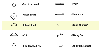
"Among the symbols used by the Lenai Lenape or Delaware
Indians in their historical / religious record, the "Wallam Olum",
both the symbols "Onan" and "Toan" appear, with very similar
translations."
|
|
Remembering an old Sherlock Holmes quote...
" ...when you have eliminated the impossible,
whatever remains,
however improbable, must be the truth. "
------ Sir Arthur Conan
Doyle (1859 - 1930), (Sherlock Holmes)
After this, team members began looking more closely for correlations
between the marks, and this Paleo-Hebraic Kabalah' translation. They have
found some amazing correlations..
{description of Zub Zool pointing to mountains page}
Original
Press Release
June 25th 1997
WATER TRAILS OF THE ANASAZI
Http://144.38.20.128/cody/bobby.html
In
October of 1996, photographer Bob Ford of Fredonia AZ, made what could be considered
one of the most amazing discoveries in modern American archeology, by identifying
a system of universal trail markings, thought to guide travelers to water, as
they cross the Arizona Strip, left by it's first known inhabitants, the Anasazi
Indians.
Bob has discovered a system
of petroglyphs used by the Anasazi to navigate in the desert
a bit like a modern
map of a particular motel chain around the nation, where a traveler can look
at the map and decide which direction they might travel to be assured they will
have another place to stay for the night
Only with the Anasazi, accommodations
were not the issue, water was. The single most important factor while
traveling across the Arizona Strip was, and still is, where to get water next.
In
many ways it makes sense that someone like Bob would make such a discovery.
Where other men go home and watch football after work, Bob goes home, gathers
his photographic equipment and heads out to catch a few pictures before the
sun goes down. He has combined his love for photography with the easy accessibility
of the Arizona Strip and amateur archeology. Over his lifetime Bob has
visited several hundred native American sites on "The Strip" which covers Northern
Arizona, Southern Utah and Southeastern Nevada. His extensive knowledge
comes from 30 years of experience in the field taking photographs of sites in
the area.
This field experience
is what allowed him, from the sheer mass of sites he is familiar with, to begin
to make the mental connections between glyphs and sites and their geographical
relation to others in the same area.
Bob relates that one afternoon,
as he was photographing some glyphs, he noticed that a certain glyph was pointing
toward a single tree on the horizon. A notable instance considering how
few trees exist on the strip, but what caught his attention was that this tree
was only visible at this exact point because of a "saddle" in the ridge of the
horizon.
Bob says it struck
him as add because he was sure he had photographed another site, some 25 plus
miles away, on the other side of the ridge, that had the same glyph,
and he thought it pointed at the same saddle
could it be pointing back
this same way?
About this same
time, he was reading in the journal of Major john Wesley Powell, and Bob says
an off the cuff comment from the Major got him started putting the pieces together..
While on one of
his later surveying expeditions on the Arizona Strip, Powell took "a very old
Indian" guide. Powell mentions specifically how, from time to time, their
guide would leave the group, ascend some butte or bluff, scout around for a
while looking at the ground and then the horizon, come back and announce simply
"we travel this way to find water". Powell, jokingly, wrote that "perhaps
he goes up to talk to the rocks
"
But Bob knew that water was no joking matter on The Strip. This Indian
guide was clearly able, while traveling in territory he had never seen, to find
water
Bob wondered if perhaps
Powell's guide wasn't "talking" to the rocks
but perhaps he was "reading"
them
Bob started comparing mental notes and photographs he had taken
over the year at several hundred sites
and he found a pattern
To help expand the theory he recruited the help of Dixon Spendlove, another
amateur archaeologist in the area. Dixon knew of several similar glyphs on other
sites and together they began a systematic survey, photographing, cataloging
and mapping glyphs and the locations they pointed to.
The system they have discovered is nothing short of incredible. At each
location of a glyph, there will be an indicated direction or directions (sometimes
there are more than one glyph on a site ) to travel to be sure to encounter
water, either at a spring, a water pocket cache or another settlement.
When that destination is reached, there are more glyphs on a nearby ridge (usually
very close, sometimes right on top), indicating where to travel next.
While the full extent
and use of these glyphs is not known, to date, these men have located, logged
and photographed more than one hundred instances of this petroglyph and many
of the water sources they point to, in three different states throughout the
entire homeland of the Anasazi.
By following these directions, a person can literally cross the entire Arizona
Strip, from House Rock Valley in Arizona on the East, to Beaver Dam in Nevada
on the West. By following these "line-of-sight" directions, travelers can find
water sources, natural water caches and/or villages.
Bob & Dixon
are currently cataloging the location of all the known glyphs and are in the
process they are finding new sites, by simply following this system of writing
in the desert.
Dixon relates: "The other day I was telling some of the local morning
coffee drinkers about our findings and several people were skeptical.
I finally told them to come see for themselves. So, after work we agreed
to follow a know glyph to the indicated location, which none of us had ever
visited. If the theory was correct, then not only should we find water,
but we should also find another glyph indicating the next spring. So we
went, found the water and the next glyph
They stopped heckling."
"This thing
is serious." He continues, "We're at the point now, that if we were to
find the petroglyph on a site and NOT find water, I would say the water has
dried up since they [the Anasazi] were here
we're that sure."
Suggested
Reading:
Although we do not cite from it, Early in the spring
of 2001, Bob Ford brought our attention to a book called "The
Name Of God", written and published by Dr. James Harrison, retired
professor from Brigham Young University.
In this book, Dr. Harrison points out that many of the writings
of the Anasazi& Hohokam cultures in the american southwest are very similar
to known "Old-Negev", inscriptions in the Sinai Desert. Dr. Harrison
believes that "Old-Negev" a Proto-Hebraic script that descended from
earlier Proto-Sinaitic and Proto-Canaanite writings, and backs up this theory
with many illustrations showing similarities between inscriptions in the Sinai
desert in the old world and native american petroglyphs in the american southwest,
including several "star of david" inscriptions.
.The cover of his book shows an inscription from the Sinai Desert
which contains one of these waterglyphs. At least 14 times, while working with
inscriptions from the american south west, Dr. Harrison translates the glyph
as Paleo-Hebraic letter "Kolph". For what should be obvious reasons,
Dr. Harrison's work is not accepted among "main stream" historians
and archeologists. But then, neither is theKensington
Stone.
The Kensington Rune stone is a slab of Graywacke stone, grey in
color, measuring 36 inches long, 16 inches wide, and 6 inches thick. It contains
runic writing along the face of the stone and along one edge. The stone was
found on the property of a Minnesota farmer named Olaf Ohman in November of
1898. When examined by runic scholars, the stone contained an account of Norse
explorers from the 14th Century.
"Eight Goths and 22 Norwegians on a journey of exploration from
Vinland very far west. We had camp by two rocky islands one day's journey north
from this stone. We were out fishing one day. After we came home we found ten
men red with blood and dead. AVM save from evil. Have ten men by the sea to
look after our ships fourteen days' journey from this island. Year 1362"
The runic scholars who originally examined the Kensington
Rune Stone (KRS) were convinced of the stone's in-authenticity primarily because
of a single runic letter found in the inscription that looks somewhat like a
combination of our modern english letters "F" & "J".
In 1951, Erik Moltke, the official Runologist of the Danish National
Museum, cited this "invented" letter as the conclusive proof of the The
Kensington Runestone's in-authenticity: "The
fact is that this letter 'j' is a development within the Latin alphabet (like
v). Both letters were invented by the French philosopher Petrus Ramus in the
16th century." and cannot, therfore, be considered authentic.
However, in 1987, Richard Nielsen, writing in vol. 16 of Epigraphic Society
Occasional Papers, pointed out no less than 8 uses of this admittedly rare symbol
in the Codex Runicus. It was therefore, unbeknownst to Moltke, an authentic
14th century nordic rune, and not a newly invented J-rune at all.
What interests our research team the most, is that half way down, nearly in
the center of the inscription, one can clearly see a waterglyph complete with
accompanying dot. Critics would argue that this symbol could have been copied
from any of a hundred different places by anyone with access to ancient old-world
texts, but then the argument comes full circle, what is an old-world rune doing
carved 128 times on mesas around the american southwest?
For further reading about other discoveries of pre-columbus finds
of ancient contact between the old and new world, our research team would suggest
the following web sites:
Some Archaeological Outliers: As long as it's possible, we should disregard
authority whenever the observations disagree with it. -- Richard P. Feynman
Writing
in Ancient Times: Jewish
Heritage: Online magazine, June 2001, Sivan 5761, Vol. 4 Edition 6 -
Excerpted From: The Hebrew Book, ed. by Raphael Posner and Israel Ta-shema,
Keter Publishing House., Jerusalem, 1975. Based on articles in the Encyclopedia
Judaica.
Who
Really Discovered America?: A
stone in a dry creek bed in New Mexico, discovered by early settlers in the
region, is one of the most amazing archaeological discoveries in the Western
Hemisphere. It contains engraved on its flank the entire Ten Commandments
written in ancient Hebrew script!
CARTHAGINIANS
IN THE NEW WORLD: Evidence
of ancient explorers traveling to the new world does exist, and more than a
single anomaly.
Phoenician
Sea and Land Voyages and Routes: When the power
of Carthage flourished, Hanno sailed round from Cádiz to the extremity of Arabia,
and published a memoir of his voyage of his voyage, as did Himilco when he was
dispatched at the same date to explore the outer coasts of Europe.
Los
Lunas Stone in New Mexico: At the foot of a "Mystery
Mountain" there is an inscription written in paleo-Hebrew. The inscription
contains a slightly abridged version of the Decalogue or Ten Commandments.
The
Bat Creek Stone:
In 1971, Cyrus Gordon identified the letters inscribed on the stone as Paleo-Hebrew
of approximately the first or second century A.D. According to him, the five
letters to the left of the comma-shaped word divider read, from right to left,
LYHWD, or "for Judea."
The Grave
Creek Stone: The Grave Creek Stone was discovered in 1838 during the excavation
of the Grave Creek Mound, in Moundsville, West Virginia, on the Ohio River.
The
Phoenician coin contains a map of the ancient world: If
Mark McMenamin is correct, neither Columbus nor the Vikings were the first non-natives
to set foot on the Americas. Working with computer-enhanced images of
gold coins, is map of the ancient world, including the area surrounding
the Mediterranean Sea and the land mass representing the Americas.
The Newark, Ohio Decalogue
and Keystone Stones: In November of 1860, David Wyrick of Newark, Ohio found
an inscribed stone in a burial mound about 10 miles south of Newark. The stone
is inscribed on all sides with a condensed version of the Ten Commandments or
Decalogue, in a peculiar form of post-Exilic square Hebrew letters.
America's Mysterious Furnaces:
Scientific evidence of prehistoric Indian copper casting was published
in an article in North American Archaeologist, written by an Evanston, IL dentist,
Ellis J. Neiburger, a man who became interested in metallurgy while in dental
school. This paper offers xeroradiographic proof of ancient casting.
Works Cited
Books
"Written by the Finger of God", Joe Sampson,
Wellspring Publishing and Distributing, P.O. Box 1113, Sandy, Utah 84091
The Hopi Survival Kit, Thomas E. Mails,
Stewart, Tabori & Chang, New York - Distributed in North America by Welcome
Rain publishing, LOC #96-61237 p.48 "The Migration"
The Story of the Book of Abraham; mummies,
manuscripts, and mormonism, H. Donl Peterson, Deseret Book Company, Salt Lake
City, Utah 1995
A Guide to the Joseph Smith Papyri,
John Gee, The Foundation for Ancient Research and Mormon Studies (FARMS), Brigham
Young University, Provo, Utah 2000
Web Sites
University of Maryland , "History
of the alphabets" , Prof. Robert Fradkin, The evolution of
the Phoenician/Greek/Proto-Sinaitic/Aramaic/Hebrew character
sets.
Dr. David Lancy,
"The Walam Olum", Anthro 3170 Fall 1999, Utah
state University. http://www.usu.edu/anthro/ origins_of_writing/walam_olum/optimized/17_unlocking.gif
Kerry A. Shirts, Book
of Abraham Links, Barry's Early Christianity and Mormonism Page
Urim and
Thummim
And I, Abraham, had
the Urim and Thummim, which the Lord my God had given me.
(Pearl
of Great Price, Abr. 3:13)
when Saul inquired
of the Lord, the Lord answered him not, neither by dreams, nor by Urim,
nor by prophets. (Holy bible, 1 Sam. 28:6)
Also, that there were
two stones in silver bowsand these stones, fastened to a breastplate, constituted
what is called the Urim and Thummimdeposited with the plates; and the
possession and use of these stones were what constituted seers in ancient
or former times; and that God had prepared them for the purpose of translating
the book. (Pearl of Great Price, JSH 1:3435)
Oliver
Cowdery is reported to have testified in court that the
Urim and Thummim enabled Joseph to read in English, the reformed Egyptian
characters, which were engraved on the plates (Mormonites,
Evangelical Magazine and Gospel Advocate, 9 Apr. 1831)
Appendix A
SACRIFICIAL
STONE OR SOMETHING ELSE?
by Roycce Young
Scattered
amongst the cliffs of Kane County is a saga of precisely similar Indian puzzles.
These "sacrificial stones" are near of above indian sites and shipped into a
flat rock at the cliff's rim.
These stone etchings were
carved deep to survive weather. All have a circle approximately 16 to
24 inches in diameter with a deep hole usually in the center or somewhere on
the bisecting line that passes through the circle and extends out for several
feet. Some have a quarter moon as illustrated in the accompanying photo.
The term "sacrificial"
comes from the South Sea Islands where similar stone etchings were used, according
to the native, for sacrificial purposes. The first one found above indian scenes
at Vaughn Judd's ranch (now Bob McKay's) points directly toward Montezuma's
Gold Mines.
Tamenes, bearers of the
gold, were supposedly sacrificed to the gods with their blood let out upon this
flat surface. Lending authority to blood letting is the fact that every
stone's bisecting trough continues until it dips off the cliff or into a large
fissure.
With such credence, lending
authority to Montezuma's gold, the varsity scouts determined they might have
something to do with a map of the treasure; so consequently, the began a pilgrimage,
hiking the rims for sacrificial stones.
Would you believe three
stones found in Johnson's Canyon point to Montezuma's mine? five stones
in hog, tinny and Kanab Canyons point in the direction of the submerged treasure
at Three Lakes.
Our good geologist friend,
Roger Holland, who keeps fact and adventure in the right priority, has been
taking compass bearings on some of these sacrificial stones. He believes
they are solstices. Since snow has covered
the mountains this winter, the boys simply sat down with a compass, drew the
sacrificial stones on a map as to their best recollections, oriented the map
with the compass, and discovered that all the sacrificial puzzles found thus
far point in either one of tow directions (North Westerly or South Easterly)
Roger holland now has some
disciples. you see, town solstices occur
each year in our hemisphere. Summary, June 21 and winter, about December
21. The rising winter sun casts its shadow in a North Westerly direction.
The setting winter sun casts its shadow in a North Easterly direction.
If the Anasazi had weather
similar to what we've had lately, and indian would have made several trips to
his solstice to be sure it was still winter.
We hope to fine some summer
solstices but I have my doubts. Could not these stone puzzles have served
two purposes since sacrifice was probably made to a SUN GOD?!!
Anyhow, there's mystery
in "them thar hills", enchanting enough to entertain men and help boys turn
into men.